Where we fish
About Hrušovská dam
About Hrušovská dam

Information
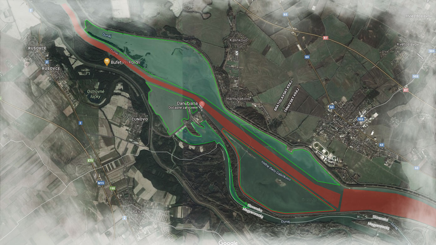
The Hrušovská reservoir is part of the Gabčíkovo Waterworks since it begun operation in 1992. It was in this area, in the vicinity of the former Hrušov settlement, that the Waterworks damaged the Danube riverbank forests the most – the left branches of the Danube and the forests from Kalinkov to Mliečno (part of Šamorín) were flooded. Instead of an extensive and articulated river stream system, there
is a vast body of water with an area of approximately 25 square kilometres.
Over the course of time the situation improves slightly by the fact that the deposition of extracted sediments created the so-called bird islands. Together with the shallow bay at Kalinkov they provide nesting and wintering space for many species of water birds. The Hrušovská reservoir is part of the Danube’s Protected Bird Area.
Danube no. 3 – 2-0610-1-1 (character of the district: carp – fishing)
The water area on the left side of the resevoir from the outlet of the pipeline from the ČOV Šamorín near the village of Čilistov Bratislava countryside, after rkm 1862 and the adjacent water areas connected to the reservoir (outside Rusovecko – Jarovecká system of arms – separate district no. 1-0130-1-1). The water area of the reservoir on the right side from pkm 29 VD (“Stop sport sailing” sign) to rkm 1862 and the adjacent water areas connected to the reservoir. The district is not a border water. Increased minimum / maximum fishing rate in cm: Great Zander 55 /, Great Catfish 90 / x, Common barbel 50 / x, Squalius Cephalus 35 / x, Ide or Orfe 35 / x, Common Dace 25 / x, Asp (predatory boletus) 50 / x, European green perch x / 10.
Increased minimum / maximum fishing rate in cm: example – Zander 55 / x.
Explanation: The number 55 in place of the minimum fishing rate means that the statutory minimum fishing rate for the great Zander has been increased to 35 cm. The letter x in place of the maximum fishing rate indicates that the maximum fishing rate of the Great Zander has not been set. This means that you can appropriate a Great Zander as long as its length is at least 55 centimeters.
Fishing from boats is allowed. During the voyage on the Danube River, it is necessary to comply with all current regulations on inland navigation and to monitor the current navigation measures imposed by the Transport Authority of the Slovak Republic.
It is possible to catch practically all lowland fish species that occur in Slovakia in the Danube River. The most common are Carp, Grass Carp, Catfish, Zander, Bream and Marl (Common Barbel). During the targeted fishing, you can also successfully hunt for Burbot in the winter. Other common fish species include all species of Squalius, Nase, Asps, Northern Pike.
Permitted hunting methods according to Act no. 216/2018 Coll. on fisheries and its implementing decree no. 381/2018 Z.z..
At the VD Hrušov – Čunovo reservoir, there are several options where it is possible to launch a boat on the water surface. On the left side, you must go through the ramp for which you will need to obtain an electronic chip, which you can get at the Ministry of
Defense SRZ Dunajská Lužná and MO SRZ Šamorín. On the right side there are freely accessible places to launch the boat at the Danubiane and Rusovecko – Jarovecká arm system.
Permits are sold daily, weekly and seasonally. For non-members of SRZ daily and weekly.
In addition to fishing, there are several ways to spend time effectively in the vicinity. The capital of Slovakia, Bratislava, is within easy reach, and in the vicinity of the reservoir there are the towns of Šamorín, Hamuliakovo, Rusovce and Čunovo. Sports activities can be performed in the X-Bionic Sphere Olympic sports complex in Šamorín, or in water sports facilities. Of the cultural opportunities, the Danubian Museum of Modern Art, located directly on the peninsula of the reservoir, is worth mentioning. Of course, there are many other interesting opportunities within reach, whether accommodation, culinary, recreational, cultural …
Source: www.srzrada.sk
Information > Guest permits for 2021
* contact us for more info